New York City is located in the Northeastern United States, in southeastern New York State, approximately halfway between Washington, D.C. and Boston. The location at the mouth of the Hudson River, which feeds into a naturally sheltered harbor and then into the Atlantic Ocean, has helped the city grow in significance as a trading city. Much of New York is built on the three islands of Manhattan, Staten Island, and Long Island, making land scarce and encouraging a high population density.
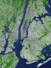
The Hudson River flows through the Hudson Valley into New York Bay. Between New York City and Troy, New York, the river is an estuary.[39] The Hudson separates the city from New Jersey. The East River – a tidal strait – flows from Long Island Sound and separates the Bronx and Manhattan from Long Island. The Harlem River, another tidal strait between the East and Hudson Rivers, separates Manhattan from the Bronx.
The city's land has been altered substantially by human intervention, with considerable land reclamation along the waterfronts since Dutch colonial times. Reclamation is most prominent in Lower Manhattan, with developments such as Battery Park City in the 1970s and 1980s.[40] Some of the natural variations in topography have been evened out, especially in Manhattan.[41]
The city's land area is estimated at 304.8 square miles (789 km2).[3][4] Its total area is 468.9 square miles (1,214 km2). 164.1 square miles (425 km2) of this are water and 304.8 square miles (789 km2) is land. The highest point in the city is Todt Hill on Staten Island, which, at 409.8 feet (124.9 m) above sea level, is the highest point on the Eastern Seaboard south of Maine.[42] The summit of the ridge is mostly covered in woodlands as part of the Staten Island Greenbelt.[43]
Climate
Under the Köppen climate classification, New York City has a humid subtropical climate and enjoys an average of 234 days with at least some sunshine annually, for an average of 2680 hours of sunshine per year.[44] When using the 0°C (American scientist standard) isotherm as criterion, it is the northernmost major city in North America that features a humid subtropical climate.Summers are typically hot and humid with average high temperatures of 79 °F (26.1 °C) to 84 °F (28.9 °C) and lows of 63 °F (17.2 °C) to 69 °F (20.6 °C), however temperatures exceed 90 °F (32 °C) on average of 16 – 19 days each summer and can exceed 100 °F (38 °C) every 4–6 years.[45] Winters are cold, and prevailing wind patterns that blow offshore minimizes the effect of the Atlantic Ocean. Yet, the Atlantic Ocean keeps the city warmer in the winter than inland North American cities located at similar latitudes such as Chicago, Pittsburgh and Cincinnati. The average temperature in January, New York City's coldest month, is 32.1 °F (0.1 °C). However temperatures in winter could for few days be as low as 10 °F (−12 °C) and as high as the 50s °F (10-15 °C).[46] Spring and autumn are unpredictable, and can range from chilly to warm, although they are usually pleasantly mild with low humidity.
New York City receives 49.7 inches (1,260 mm) of precipitation annually, which is fairly spread throughout the year. Average winter snowfall is about 28.1 inches (71 cm), but this usually varies considerably from year to year, and snow cover usually remains little.[44] Hurricanes and tropical storms are rare in the New York area, but are not unheard of and always have the potential to strike the area.
| [hide]Month | Jan | Feb | Mar | Apr | May | Jun | Jul | Aug | Sep | Oct | Nov | Dec | Year |
|---|---|---|---|---|---|---|---|---|---|---|---|---|---|
| Record high °F (°C) | 72 (22) | 75 (24) | 86 (30) | 96 (36) | 99 (37) | 101 (38) | 106 (41) | 104 (40) | 102 (39) | 94 (34) | 84 (29) | 75 (24) | 106 (41) |
| Average high °F (°C) | 38.0 (3.3) | 41.0 (5) | 49.8 (9.9) | 60.7 (15.9) | 70.9 (21.6) | 79.0 (26.1) | 84.2 (29) | 82.4 (28) | 74.7 (23.7) | 63.5 (17.5) | 53.1 (11.7) | 42.9 (6.1) | 61.7 (16.5) |
| Daily mean °F (°C) | 32.1 (0.1) | 34.6 (1.4) | 42.5 (5.8) | 52.5 (11.4) | 62.6 (17) | 71.2 (21.8) | 76.5 (24.7) | 75.1 (23.9) | 67.5 (19.7) | 56.6 (13.7) | 47.1 (8.4) | 37.3 (2.9) | 54.6 (12.6) |
| Average low °F (°C) | 26.2 (-3.2) | 28.1 (-2.2) | 35.1 (1.7) | 44.2 (6.8) | 54.2 (12.3) | 63.3 (17.4) | 68.8 (20.4) | 67.7 (19.8) | 60.3 (15.7) | 49.6 (9.8) | 41.0 (5) | 31.6 (-0.2) | 47.5 (8.6) |
| Record low °F (°C) | -6 (-21) | -15 (-26) | 3 (-16) | 12 (-11) | 28 (-2) | 44 (7) | 52 (11) | 50 (10) | 39 (4) | 28 (-2) | 7 (-14) | -13 (-25) | -15 (-26) |
| Precipitation inches (mm) | 4.13 (104.9) | 3.15 (80) | 4.37 (111) | 4.28 (108.7) | 4.69 (119.1) | 3.84 (97.5) | 4.62 (117.3) | 4.22 (107.2) | 4.23 (107.4) | 3.85 (97.8) | 4.36 (110.7) | 3.95 (100.3) | 49.69 (1,262.1) |
| Snowfall inches (cm) | 7.5 (19.1) | 8.4 (21.3) | 5.0 (12.7) | 0.9 (2.3) | 0 (0) | 0 (0) | 0 (0) | 0 (0) | 0 (0) | 0 (0) | 0.9 (2.3) | 5.4 (13.7) | 28.1 (71.4) |
| Avg. snowy days | 4.1 | 2.9 | 1.6 | 0.2 | 0 | 0 | 0 | 0 | 0 | 0 | 0.3 | 1.8 | 10.9 |
| Avg. precipitation days | 10.3 | 9.4 | 10.7 | 11.1 | 11.4 | 10.8 | 10.2 | 9.5 | 9.1 | 8.3 | 9.3 | 10.6 | 120.7 |
| Source: NOAA [47] Weatherbase.com [48] August 2009 | |||||||||||||
Environment
Mass transit use in New York City is the highest in the United States, and gasoline consumption in the city is the same rate as the national average in the 1920s.[49] New York City's high level of mass transit use saved 1.8 billion gallons of oil in 2006; New York saves half of all the oil saved by transit nationwide.[50] The city's population density, low automobile use and high transit utility make it among the most energy efficient cities in the United States.[51] New York City's greenhouse gas emissions are 7.1 metric tons per person compared with the national average of 24.5.[52] New Yorkers are collectively responsible for one percent of the nation's greenhouse gas emissions[52] though they comprise 2.7% of the nation's population. The average New Yorker consumes less than half the electricity used by a resident of San Francisco and nearly one-quarter the electricity consumed by a resident of Dallas.[53]
In recent years, the city has focused on reducing its environmental impact. Large amounts of concentrated pollution in New York City led to a high incidence of asthma and other respiratory conditions among the city's residents.[54] The city government is required to purchase only the most energy-efficient equipment for use in city offices and public housing.[55] New York has the largest clean air diesel-hybrid and compressed natural gas bus fleet in the country, and some of the first hybrid taxis.[56] The city government was a petitioner in the landmark Massachusetts v. Environmental Protection Agency Supreme Court case forcing the EPA to regulate greenhouse gases as pollutants. The city is also a leader in the construction of energy-efficient green office buildings, including the Hearst Tower among others.[57]
New York City is supplied with drinking water by the protected Catskill Mountains watershed.[58] As a result of the watershed's integrity and undisturbed natural water filtration system, New York is one of only four major cities in the United States with drinking water pure enough not to require purification by water treatment plants.[59]