Search Term:

Saturday, February 13, 2010

Washington: Part of Worldtour

State of Washington
Flag of Washington State seal of Washington
Flag Seal
Nickname(s): The Evergreen State
Motto(s): Alki (Chinook Wawa: "Eventually" or "By and by")[1]
before statehood, known as
the Washington Territory
Map of the United States with Washington highlighted
Demonym Washingtonian
Capital Olympia
Largest city Seattle
Area Ranked 18th in the US
- Total 71,342 sq mi
(184,827 km2)
- Width 240 miles (400 km)
- Length 360 miles (580 km)
- % water 6.6
- Latitude 45° 33′ N to 49° N
- Longitude 116° 55′ W to 124° 46′ W
Population Ranked 13th in the US
- Total 6,664,195 (2009 est.)[2]
- Density 88.6/sq mi (34.20/km2)
Ranked 25th in the US
- Median income $53,515 (13th)
Elevation
- Highest point Mount Rainier[3]
14,411 ft (4,395 m)
- Mean 1,700 ft (520 m)
- Lowest point Pacific Ocean[3]
0 ft (0 m)
Admission to Union November 11, 1889 (42nd)
Governor Christine Gregoire (D)
Lieutenant Governor Brad Owen (D)
U.S. Senators Patty Murray (D)
Maria Cantwell (D)
U.S. House delegation 6 Democrats, 3 Republicans (list)
Time zone Pacific: UTC-8/-7
Abbreviations WA US-WA
Website http://access.wa.gov

Washington: Geography

A land of contrasts: a farm and barren hills near Riverside.

Washington is the northwestern-most state of the contiguous United States. Its northern border lies mostly along the 49th parallel, and then via marine boundaries through the Strait of Georgia, Haro Strait and Strait of Juan de Fuca, with the Canadian province of British Columbia to the north. Washington borders Oregon to the south, with the Columbia River forming most of the boundary and the 46th parallel forming the eastern part of the southern boundary. To the east Washington borders Idaho, bounded mostly by the meridian running north from the confluence of the Snake River and Clearwater River (about 116°57' west), except for the southernmost section where the border follows the Snake River. To the west of Washington lies the Pacific Ocean.[4] Washington was a Union territory during the American Civil War, although it never actually participated in the war.

Washington is part of a region known as the Pacific Northwest, a term which always includes at least Washington and Oregon and may or may not include Idaho, western Montana, northern California, and part or all of British Columbia, Alaska, and the Yukon Territory, depending on the speaker or writer's intent.

Digitally colored elevation map of Washington.

The high mountains of the Cascade Range run north-south, bisecting the state. Western Washington, west of the Cascades, has a mostly marine west coast climate with relatively mild temperatures, wet winters, and dry summers. Western Washington also supports dense forests of conifers and areas of temperate rain forest.[5] In contrast, Eastern Washington, east of the Cascades, has a relatively dry climate with large areas of semiarid steppe and a few truly arid deserts lying in the rainshadow of the Cascades; the Hanford reservation receives an average annual precipitation of between six and seven inches (178 mm). Farther east, the climate becomes less arid. The Palouse region of southeast Washington was grassland that has been mostly converted into farmland. Other parts of eastern Washington are forested and mountainous.

The Cascade Range contains several volcanoes, which reach altitudes significantly higher than the rest of the mountains. From the north to the south these volcanoes are Mount Baker, Glacier Peak, Mount Rainier, Mount St. Helens, and Mount Adams. Mount St. Helens is currently the only Washington volcano that is actively erupting; however, all of them are considered active volcanoes.

Washington's position on the Pacific Ocean and the harbors of Puget Sound give the state a leading role in maritime trade with Alaska, Canada, and the Pacific Rim. Puget Sound's many islands are served by the largest ferry fleet in the United States.

Washington is a land of contrasts. The deep forests of the Olympic Peninsula, such as the Hoh Rain Forest, are among the only temperate rainforests in the continental United States, but the semi-desert east of the Cascade Range has few trees. Mount Rainier, the highest mountain in the state,[3] is covered with more glacial ice than any other peak in the lower 48 states.[6]

Federal land and reservations

National parks and monuments

There are three National Parks and two National Monuments in Washington:

  • Mount Rainier National Park
  • North Cascades National Park
  • Olympic National Park
  • Mount St. Helens National Volcanic Monument
  • Hanford Reach National Monument

National forests

Nine national forests are located (at least partly) in Washington:

  • Colville National Forest
  • Gifford Pinchot National Forest
  • Idaho Panhandle National Forest
  • Kaniksu National Forest
  • Mount Baker-Snoqualmie National Forest
  • Okanogan National Forest
  • Olympic National Forest
  • Umatilla National Forest
  • Wenatchee National Forest

Federally protected wildernesses

31 wildernesses are located (at least partly) in Washington, including:

  • Alpine Lakes Wilderness
  • Glacier Peak Wilderness
  • Goat Rocks Wilderness
  • Henry M. Jackson Wilderness
  • Juniper Dunes Wilderness
  • Lake Chelan-Sawtooth Wilderness
  • Mount Baker Wilderness
  • Norse Peak Wilderness
  • Olympic Wilderness
  • Pasayten Wilderness
  • Wild Sky Wilderness

National wildlife refuges

23 National Wildlife Refuges are located (at least partly) in Washington including:

  • Dungeness National Wildlife Refuge
  • Little Pend Oreille National Wildlife Refuge
  • Nisqually National Wildlife Refuge
  • Ridgefield National Wildlife Refuge
  • Saddle Mountain National Wildlife Refuge
  • San Juan Islands National Wildlife Refuge
  • Turnbull National Wildlife Refuge
  • Willapa National Wildlife Refuge

Other federally protected lands

Other protected lands of note include:

  • Columbia River Gorge National Scenic Area
  • Ebey's Landing National Historical Reserve
  • Fort Vancouver National Historic Site
  • Klondike Gold Rush National Historical Park
  • Lake Chelan National Recreation Area
  • Lake Roosevelt National Recreation Area
  • Ross Lake National Recreation Area
  • San Juan Island National Historical Park
  • Whitman Mission National Historic Site
  • 17 National Natural Landmarks

Military and related reservations

There are several large military-related reservations, including:

  • JBLM Joint Base Lewis-McChord
  • Fairchild Air Force Base
  • Naval Base Kitsap
  • Hanford Site
  • Yakima Training Center
  • Puget Sound Naval Shipyard and Intermediate Maintenance Facility (Bremerton)
  • Naval Air Station Whidbey Island
  • Naval Station Everett

Climate

Dryland farming caused a large dust storm in arid parts of eastern Washington on October 4, 2009. Courtsey: NASA/GSFC, MODIS Rapid Response[7]

Washington's climate varies greatly from west to east. An oceanic climate (also called "west coast marine climate") predominates in western Washington, and a much drier semi-arid climate prevails east of the Cascade Range. Major factors determining Washington's climate include the large semi-permanent high pressure and low pressure systems of the north Pacific Ocean, the continental air masses of North America, and the Olympic and Cascade mountains. In the spring and summer, a high pressure anticyclone system dominates the north Pacific Ocean, causing air to spiral out in a clockwise fashion. For Washington this means prevailing winds from the northwest bringing relatively cool air and a predictably dry season. In the autumn and winter, a low pressure cyclone system takes over in the north Pacific Ocean, with air spiraling inward in a counter-clockwise fashion. This causes Washington's prevailing winds to come from the southwest, bringing relatively warm and moist air masses and a predictably wet season. The term Pineapple Express is used to describe the extreme form of this wet season pattern.[8]

Despite western Washington having a marine climate similar to those of many coastal cities of Europe, there are exceptions such as the "Big Snow" events of 1880, 1881, 1893 and 1916 and the "deep freeze" winters of 1883–84, 1915–16, 1949–50 and 1955–56, among others. During these events western Washington experienced up to 6 feet (1.8 m) of snow, sub-zero (−18°C) temperatures, three months with snow on the ground, and lakes and rivers frozen over for weeks.[9] Seattle's lowest officially recorded temperature is 0 °F (−18 °C) set on January 31, 1950, but areas a short distance away from Seattle have recorded lows as cold as −20 °F (−28.9 °C).[citation needed]

In 2006, the Climate Impacts Group at the University of Washington published The Impacts of Climate change in Washington’s Economy, a preliminary assessment on the risks and opportunities presented given the possibility of a rise in global temperatures and their effects on Washington state.[10]

Rain shadow effects

Washington experiences extensive variation in rainfall

The coastal mountains and Cascades compound this climatic pattern by causing orographic lift of the air masses blown inland from the Pacific Ocean, resulting in the windward side of the mountains receiving high levels of precipitation and the leeward side receiving low levels. This occurs most dramatically around the Olympic Mountains and the Cascade Range. In both cases the windward slopes facing southwest receive high precipitation and mild, cool temperatures. While the Puget Sound lowlands are known for clouds and rain in the winter, the western slopes of the Cascades receive larger amounts of precipitation, often falling as snow at higher elevations. (Mount Baker, near the state's northern border, is one of the snowiest places in the world: in 1999, it set the world record for snowfall in a single season: 1,140 inches, or 95 foot (29 m).[11] East of the Cascades, a large region experiences strong rain shadow effects. Semi-arid conditions occur in much of eastern Washington with the strongest rain shadow effects at the relatively low elevations of the central Columbia Plateau—especially the region just east of the Columbia River from about the Snake River to the Okanagan Highland. Thus instead of rain forests much of eastern Washington is covered with grassland and shrub-steppe.

Temperatures

The average annual temperature ranges from 51 °F (11 °C) on the Pacific coast to 40 °F (4 °C) in the northeast. The lowest recorded temperature in the state was −48 °F (−44.4 °C) in Winthrop and Mazama. The highest recorded temperature in the state was 118 °F (48 °C) at Ice Harbor Dam. Both records were set east of the Cascades. Western Washington is known for its mild climate, considerable fog, frequent cloud cover and long-lasting drizzles in the winter, and sunny and dry summers. The western region occasionally experiences extreme climate. Arctic cold fronts in the winter and heat waves in the summer are not uncommon. In the Western region, temperatures have reached as high as 112 °F (44 °C) in Marietta[12] and as low as −20 °F (−28.9 °C) in Longview.[13] The western side of the Olympic Peninsula receives as much as 160 inches (4,100 mm) of precipitation annually, making it the wettest area of the 48 conterminous states. Weeks or even months may pass without a clear day. The western slopes of the Cascade Range receive some of the heaviest annual snowfall (in some places more than 200 inches (510 cm)) in the country. In the rain shadow area east of the Cascades, the annual precipitation is only 6 inches (150 mm). Precipitation then increases again eastward toward the Rocky Mountains.

Washington: History


A reconstructed face of the Kennewick Man.
Mt. Rainier reflected in Reflection lake.
The Dalles Dam on the Columbia River
Mount Rainier with Tacoma in foreground

Prior to the arrival of explorers from Europe, this region of the Pacific Coast had many established tribes of Native Americans, each with its own unique culture. Today, they are most notable for their totem poles and their ornately carved canoes and masks. Prominent among their industries were salmon fishing and, among the Makah, whale hunting. The peoples of the Interior had a very different subsistence-based culture based on hunting, food-gathering and some forms of agriculture, as well as a dependency on salmon from the Columbia and its tributaries. The smallpox epidemic of the 1770s devastated the Amerindian population.[14]

The first European record of a landing on the Washington coast was by Spanish Captain Don Bruno de Heceta in 1775, on board the Santiago, part of a two-ship flotilla with the Sonora. They claimed all the coastal lands up to Prince William Sound in the north for Spain as part of their claimed rights under the Treaty of Tordesillas, which they maintained made the Pacific a "Spanish lake" and all its shores part of the Spanish Empire.

In 1778, British explorer Captain James Cook sighted Cape Flattery, at the entrance to the Strait of Juan de Fuca, but the straits would not be explored until 1789, by Captain Charles W. Barkley. Further explorations of the straits were performed by Spanish explorers Manuel Quimper in 1790 and Francisco de Eliza in 1791, then by British Captain George Vancouver in 1792.

The British-Spanish Nootka Convention of 1790 ended Spanish claims of exclusivity and opened the Northwest Coast to explorers and traders from other nations, most notably Britain and Russia as well as the fledgling United States. American captain Robert Gray (for whom Grays Harbor County is named) then discovered the mouth of the Columbia River. He named the river after his ship, the Columbia. Beginning in 1792, Gray established trade in sea otter pelts. The Lewis and Clark Expedition entered the state on October 10, 1805.

Explorer David Thompson, on his voyage down the Columbia River camped at the junction with the Snake River on July 9, 1811 and erected a pole and a notice claiming the country for Great Britain and stating the intention of the North West Company to build a trading post at the site.

The UK and the USA agreed to what has since been described as "joint occupancy" of lands west of the Continental Divide to the Pacific Ocean as part of the Anglo-American Convention of 1818, which established the 49th Parallel as the international boundary west from Lake of the Woods to the Rocky mountains. Resolution of the territorial and treaty issues, west to the Pacific, were deferred until a later time. Spain, in 1819, ceded their rights north of the 42nd Parallel to the United States, although these rights did not include possession.

Negotiations with Great Britain over the next few decades failed to settle upon a compromise boundary and the Oregon boundary dispute became important in geopolitical diplomacy between the British Empire and the new American Republic. Disputed joint-occupancy by Britain and the U.S.A., lasted for several decades. With American settlers pouring into the Oregon Country; the Hudson's Bay Company, which had previously discouraged settlement because it conflicted with the fur trade, reversed its position in an attempt to maintain control of the Columbia District for Great Britain. Fur trapper James Sinclair, on orders from Sir George Simpson, Governor of the Hudson's Bay Company, guided some 200 settlers from the Red River Colony west in 1841 to settle on Hudson Bay Company farms near Fort Vancouver. The party crossed the Rockies into the Columbia Valley, near present-day Radium Hot Springs, British Columbia, then traveled south-west down the Kootenai River and Columbia River. Despite such efforts, Britain eventually ceded all claim to land south of the 49th parallel to the United States in the Oregon Treaty on June 15, 1846.

In 1836, a group of missionaries including Marcus Whitman established several missions and Whitman’s own settlement Waiilatpu, in what is now southeastern Washington state, near present day Walla Walla County, in territory of both the Cayuse and the Nez Perce Indian tribes. Whitman’s settlement would in 1843 help the Oregon Trail, the overland emigration route to the west, get established for thousands of emigrants in following decades. Marcus provided medical care for the Native Americans, but when Indian patients – lacking immunity to new, ‘European’ diseases – died in striking numbers, while at the same time many white patients recovered, they held ‘medicine man’ Marcus Whitman personally responsible, and murdered Whitman and twelve other white settlers in the Whitman massacre in 1847. This event triggered the Cayuse War between settlers and Indians.

The first settlement in the Puget Sound area in the west of what is now Washington, was that of Fort Nisqually, a farm and trading post of the Hudson's Bay Company, in 1833. Washington's erstwhile founder, the black pioneer George Washington Bush and his caucasian wife, Isabella James Bush, from Missouri and Tennessee, respectively. They led four white families into the territory and settled New Market, now known as Tumwater, Washington, in 1846. They settled in Washington to avoid Oregon's racist settlement laws.[15] After them, many more settlers, migrating overland along the Oregon trail, wandered north to settle in the Puget Sound area.

In 1852, people from all over what was to become Washington state gathered in Monticello (now Longview) to draft a memorandum to Congress. The memorandum expressed their desire to be granted statehood under the name of Columbia. This meeting came to be known as the Monticello Convention. The desires of the Convention were met favorably in Congress, but it was decided that a state named Columbia might be confused with the preexisting District of Columbia. In a manner which strangely enough did not solve the problem of being confused with the nation's capital, the state was instead named Washington in honor of the first U.S. president.[16] Washington became the 42nd state in the United States on November 11, 1889.

Early prominent industries in the state included agriculture and lumber. In eastern Washington, the Yakima River Valley became known for its apple orchards, while the growth of wheat using dry-farming techniques became particularly productive. The heavy rainfall to the west of the Cascade Range produced dense forests, and the ports along Puget Sound prospered from the manufacturing and shipping of lumber products, particularly the Douglas-fir. Other industries that developed in the state include fishing, salmon canning and mining.

For a long period, Tacoma was noted for its large smelters where gold, silver, copper and lead ores were treated. Seattle was the primary port for trade with Alaska and the rest of the country, and for a time it possessed a large shipbuilding industry. The region around eastern Puget Sound developed heavy industry during the period including World War I and World War II, and the Boeing company became an established icon in the area.

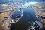
During the Great Depression, a series of hydroelectric dams were constructed along the Columbia river as part of a project to increase the production of electricity. This culminated in 1941 with the completion of the Grand Coulee Dam, the largest concrete structure in the United States.

During World War II, the state became a focus for war industries, with the Boeing Company producing many of the nation's heavy bombers and ports in Seattle, Bremerton, Vancouver, and Tacoma were available for the manufacture of warships. Seattle was the point of departure for many soldiers in the Pacific, a number of which were quartered at Golden Gardens Park. In eastern Washington, the Hanford Works atomic energy plant was opened in 1943 and played a major role in the construction of the nation's atomic bombs.

On May 18, 1980, following a period of heavy tremors and eruptions, the northeast face of Mount St. Helens exploded outward, destroying a large part of the top of the volcano. This eruption flattened the forests, killed 57 people, flooded the Columbia River and its tributaries with ash and mud, and blanketed large parts of Washington and other surrounding states in ash, making day look like night.

Washington: Demographics


Historical populations
Census Pop.
1850 1,201
1860 11,594
865.4%
1870 23,955
106.6%
1880 75,116
213.6%
1890 357,232
375.6%
1900 518,103
45.0%
1910 1,141,990
120.4%
1920 1,356,621
18.8%
1930 1,563,396
15.2%
1940 1,736,191
11.1%
1950 2,378,963
37.0%
1960 2,853,214
19.9%
1970 3,409,169
19.5%
1980 4,132,156
21.2%
1990 4,866,692
17.8%
2000 5,894,121
21.1%
Est. 2009[2] 6,664,195
13.1%
Washington Population Density Map
Seattle
Spokane
Tacoma

According to the U.S. Census, as of 2009, Washington has an estimated population of 6,664,195, which is an increase of 770,074, or 13.1%, since the year 2000.[19] This includes a natural increase of 221,958 people (that is, 503,819 births minus 281,861 deaths) and an increase from net migration of 287,759 people into the state. Immigration from outside the United States resulted in a net increase of 157,950 people, and migration within the country produced a net increase of 129,809 people. Washington ranks first in the Pacific Northwest region in terms of population, followed by Oregon, and Idaho.

The center of population of Washington in the year 2000 was located in an unpopulated part of rural eastern King County, southeast of North Bend and northeast of Enumclaw.[20]

As of the Census 2000, the Seattle-Tacoma-Bellevue Metropolitan Area's population was 3,043,878, approximately half the state's total population.[21]

As of 2004, Washington's population included 631,500 foreign-born (10.3% of the state population), and an estimated 100,000 illegal aliens (1.6% of state population).[22]

6.7% of Washington's population was reported as under 5, 25.7% under 18, and 11.2% were 65 or older. Females made up approximately 50.2% of the population.

Largest cities

The largest cities in Washington according to 2009 state census estimates.[23]

Rank City Population
1 Seattle 602,000
2 Spokane 205,500
3 Tacoma 203,400
4 Vancouver 164,500
5 Bellevue 120,600
6 Everett 103,500
7 Spokane Valley 89,440
8 Federal Way 88,580
9 Kent 88,380
10 Yakima 84,850
11 Renton 83,650
12 Bellingham 76,130
13 Auburn 67,485
14 Kennewick 67,180
15 Lakewood 58,840

Race

Demographics of Washington (csv)
By race White Black AIAN* Asian NHPI*
2000 (total population) 88.64% 4.12% 2.73% 6.75% 0.74%
2000 (Hispanic only) 7.00% 0.23% 0.28% 0.15% 0.06%
2005 (total population) 87.65% 4.45% 2.65% 7.69% 0.78%
2005 (Hispanic only) 8.16% 0.33% 0.30% 0.20% 0.07%
Growth 2000–05 (total population) 5.49% 15.37% 3.54% 21.57% 12.25%
Growth 2000–05 (non-Hispanic only) 3.88% 13.41% 2.18% 21.11% 11.20%
Growth 2000–05 (Hispanic only) 24.32% 47.88% 15.40% 41.33% 24.11%
* AIAN is American Indian or Alaskan Native; NHPI is Native Hawaiian or Pacific Islander

The seven largest reported ancestries in Washington are: German (18.7%), English (12%), Irish (11.4%), Norwegian (6.2%), Mexican (5.6%), African (4.2%), and Filipino (3.7%).

Washington has the fourth largest Asian-American population of any state. The Filipino-American community is the largest Asian American subgroup in the state. Gary Locke was elected as the first Asian American governor (and so far, the only Chinese American governor of any US state) at the end of the 20th century.

There are many migrant Mexican American farm workers living in the southeast-central part of the state, and this population is also steadily increasing in Western Washington.

African Americans are less numerous than Asian Americans or Hispanic Americans in many communities in Washington, but have been elected as mayors of Seattle, Spokane, and Lakewood, and also as King County Executive. In Seattle, many African Americans are moving into the southern part of the city, as well as to many suburban areas such as South King County. Seattle's black population is largely concentrated on Rainier Valley and the Central District, which remains one of the only majority-black neighborhoods in the Pacific Northwest, the other being in Portland, Oregon's King neighborhood; it is about 40% African-American. Tacoma also has a rising African-American population.

Washington is the location of many Native American reservations, with some placing prominent casinos next to major interstate highways. Residents have adopted many of the artwork themes of the northwest coast Indians who were noted for totem poles, longhouses, dugout canoes and pictures of animals. Many cities have traditional names created by Native Americans such as Yakima, Seattle, Spokane, Puyallup, and Walla Walla.

Religion

Major religious affiliations of the people of Washington are:[24]

  • Protestant: 49%
    • Mainline: 23%
    • Evangelical: 25%
    • Other Protestant: 1%
  • Unaffiliated: 25%
  • Roman Catholic: 16%
  • Latter-day Saint: 4%
  • Muslim: 1%
  • Jewish: 1%
  • Other Religions: 3%


The largest denominations by number of adherents in 2000 were the Roman Catholic Church with 716,133; The Church of Jesus Christ of Latter-day Saints with 178,000 (253,166 year-end 2007) ; and the Evangelical Lutheran Church in America with 127,854.[25]

As with many other Western states, the percentage of Washington's population identifying themselves as "non-religious" is higher than the national average. The percentage of non-religious people in Washington is the highest of any state other than Colorado with 31%.

Washington: Economy

Microsoft Corporation, Redmond

The 2007 total gross state product for Washington was $311.5 billion, placing it 14th in the nation.[27] The per capita personal income in 2007 was $41,203, 10th in the nation. Significant business within the state include the design and manufacture of jet aircraft (Boeing), computer software development (Microsoft, Amazon.com, Nintendo of America, Valve Corporation), electronics, biotechnology, aluminum production, lumber and wood products (Weyerhaeuser), mining, and tourism. The state has significant amounts of hydroelectric power generation.

Significant amounts of trade with Asia pass through the ports of the Puget Sound. See list of United States companies by state. Fortune magazine survey of the top 20 Most Admired Companies in the US has 4 Washington based companies in it, Starbucks, Microsoft, Costco and Nordstrom.[28]

The state of Washington has the least progressive tax structure in the U.S.[clarification needed] It is one of only seven states that does not levy a personal income tax. The state also does not collect a corporate income tax or franchise tax. However, Washington businesses are responsible for various other state levies. One tax Washington charges on most businesses is the business and occupation tax (B & O), a gross receipts tax which charges varying rates for different types of businesses.

Starbucks Headquarters, Seattle.

Washington's state sales tax is 6.5 percent, and it applies to services as well as products.[29] Most foods are exempt from sales tax; however, prepared foods, dietary supplements and soft drinks remain taxable. The combined state and local retail sales tax rates increase the taxes paid by consumers, depending on the variable local sales tax rates, generally between 8 and 9 percent.[30] An excise tax applies to certain select products such as gasoline, cigarettes, and alcoholic beverages. Property tax was the first tax levied in the state of Washington and its collection accounts for about 30 percent of Washington's total state and local revenue. It continues to be the most important revenue source for public schools, fire protection, libraries, parks and recreation, and other special purpose districts.

All real property and personal property is subject to tax unless specifically exempted by law. Personal property also is taxed, although most personal property owned by individuals is exempt. Personal property tax applies to personal property used when conducting business or to other personal property not exempt by law. All property taxes are paid to the county treasurer's office where the property is located. Washington does not impose a tax on intangible assets such as bank accounts, stocks or bonds. Neither does the state assess any tax on retirement income earned and received from another state. Washington does not collect inheritance taxes; however, the estate tax is decoupled from the federal estate tax laws, and therefore the state imposes its own estate tax.

Washington is one of eighteen states which has a government monopoly on sales of alcoholic beverages, although beer and wine with less than 20 percent alcohol by volume can be purchased in convenience stores and supermarkets. Liqueurs (even if under 20 percent alcohol by volume) and spirits can only be purchased in state-run or privately-owned-state-contracted liquor stores.[31]

Among its resident billionaires, Washington boasts Bill Gates, chairman of Microsoft, who, with a net worth of $40 billion, was ranked the wealthiest man in the world as of February 2009, according to Forbes magazine.[32] Other Washington state billionaires include Paul Allen (Microsoft), Steve Ballmer (Microsoft), Jeff Bezos (Amazon), Craig McCaw (McCaw Cellular Communications), James Jannard (Oakley), Howard Schultz (Starbucks), and Charles Simonyi (Microsoft).[33]

Agriculture

Azwell, Washington, a small community of pickers' cabins and apple orchards.

Washington is a leading agricultural state. (The following figures are from the Washington State Office of Financial Management and the USDA, National Agricultural Statistics Service, Washington Field Office.) For 2003, the total value of Washington's agricultural products was $5.79 billion, the 11th highest in the country. The total value of its crops was $3.8 billion, the 7th highest. The total value of its livestock and specialty products was $1.5 billion, the 26th highest.

In 2004, Washington ranked first in the nation in production of red raspberries (90.0% of total U.S. production), wrinkled seed peas (80.6%), hops (75.0%), spearmint oil (73.6%), apples (58.1%), sweet cherries (47.3%), pears (42.6%), peppermint oil (40.3%), Concord grapes (39.3%), carrots for processing (36.8%), and Niagara grapes (31.6%). Washington also ranked second in the nation in production of lentils, fall potatoes, dry edible peas, apricots, grapes (all varieties taken together), asparagus (over a third of the nation's production), sweet corn for processing, and green peas for processing; third in tart cherries, prunes and plums, and dry summer onions; fourth in barley and trout; and fifth in wheat, cranberries, and strawberries.

The apple industry is of particular importance to Washington. Because of the favorable climate of dry, warm summers and cold winters of central Washington, the state has led the U.S. in apple production since the 1920s.[34] Two areas account for the vast majority of the state's apple crop: the Wenatchee–Okanogan region (comprising Chelan, Okanogan, Douglas, and Grant counties), and the Yakima region (Yakima, Benton and Kittitas counties)

Washington: Transportation

Washington has the largest ferry system in the United States.

Washington has a system of state highways, called State Routes, as well as an extensive ferry system which is the largest in the nation[36] as well as the third largest in the world. There are 140 public airfields in Washington, including 16 state airports owned by the Washington State Department of Transportation. Boeing Field in Seattle is one of the busiest primary non-hub airports in the US.[37] The unique geography of Washington presents exceptional transportation needs.

There are extensive waterways in the midst of Washington's largest cites, including Seattle, Bellevue, Tacoma and Olympia. The state highways incorporate an extensive network of bridges and the largest ferry system in the United States to serve transportation needs in the Puget Sound area. Washington's marine highway constitutes a fleet of twenty-eight ferries that navigate Puget Sound and its inland waterways to 20 different ports of call. Washington is home to four of the five longest floating bridges in the world: the Evergreen Point Floating Bridge, Lacey V. Murrow Memorial Bridge and Homer M. Hadley Memorial Bridge over Lake Washington, and the Hood Canal Bridge which connects the Olympic Peninsula and Kitsap Peninsula.

Floating bridges on Lake Washington

The Cascade Mountain Range also provides unique transportation challenges. Washington operates and maintains roads over seven major mountain passes and eight minor passes. During winter months some of these passes are plowed, sanded, and kept safe with avalanche control. Not all are able to stay open through the winter. The North Cascades Highway, State Route 20, closes every year. This is because the extraordinary amount of snowfall and frequency of avalanches in the area of Washington Pass make it unsafe in the winter months.

It is recorded that transportation, including automobiles, planes, trains and ships, is the cause of 45 percent of greenhouse gas emissions in Washington.

Washington: Toxic chemicals

In 2007, Washington became the first state in the nation to target all forms of highly toxic brominated flame retardants known as PBDEs for elimination from the many common household products in which they are used. A 2004 study of 40 mothers from Oregon, Washington, British Columbia, and Montana found PBDEs in the breast milk of every woman tested.

Three recent studies by the Washington Department of Ecology showed that toxic chemicals banned decades ago continue to linger in the environment and concentrate in the food chain. In one of the studies, state government scientists found unacceptable levels of toxic substances in 93 samples of freshwater fish collected from 45 sites. The toxic substances included PCBs; dioxins, two chlorinated pesticides, DDE and dieldrin, and PBDEs. As a result of the study, the department will investigate the sources of PCBs in the Wenatchee River, where unhealthy levels of PCBs were found in mountain whitefish. Based on the 2007 information and a previous 2004 Ecology study, the Washington Department of Health is advising the public not to eat mountain whitefish from the Wenatchee River from Leavenworth downstream to where the river joins the Columbia, due to unhealthy levels of PCBs. Study results also indicated high levels of contaminants in fish tissue that scientists collected from Lake Washington and the Spokane River, where fish consumption advisories are already in effect[3].

On March 27, 2006 Governor Christine Gregoire signed into law the recently approved House Bill 2322. This bill would limit phosphorus content in dishwashing detergents statewide to 0.5% over the next six years. Though the ban would be effective statewide in 2010, it would take place in Whatcom County, Spokane County, and Clark County in 2008.[39] A recent discovery had linked high contents of phosphorus in water to a boom in algae population. An invasive amount of algae in bodies of water would eventually lead to a variety of excess ecological and

Washington: Law and government

The Washington State Capitol in Olympia.

The bicameral Washington State Legislature is the state's legislative branch. The state legislature is composed of a lower House of Representatives and an upper State Senate. The state is divided into 49 legislative districts of equal population, each of which elects two representatives and one senator. Representatives serve two-year terms, whilst senators serve for four years. There are no term limits. Currently, the Democratic Party holds majorities in both chambers.

Washington's executive branch is headed by a governor elected for a four-year term. The current governor is Christine Gregoire, a Democrat who has been in office since 2005.

The Washington Supreme Court is the highest court in the state. Nine justices serve on the bench and are elected statewide.

U.S. Congress

The two U.S. Senators from Washington are Patty Murray (D) and Maria Cantwell (D).

Washington representatives in the United States House of Representatives (see map of districts) are Jay Inslee (D-1), Richard Ray (Rick) Larsen (D-2), Brian Baird (D-3), Doc Hastings (R-4), Cathy McMorris Rodgers (R-5), Norm Dicks (D-6), Jim McDermott (D-7), Dave Reichert (R-8), and Adam Smith (D-9).

State elected officials

Executive

  • Christine Gregoire, Governor (D)
  • Brad Owen, Lieutenant Governor (D)
  • Sam Reed, Secretary of State (R)
  • Rob McKenna, Attorney General (R)
  • Jim McIntire, State Treasurer (D)
  • Brian Sonntag, State Auditor (D)
  • Randy Dorn, Superintendent of Public Instruction (non-partisan office)
  • Peter J. Goldmark, Commissioner of Public Lands (D)
  • Mike Kreidler, Insurance Commissioner (D)

Politics

Presidential elections results
Year Republican Democratic
2008 40.48% 1,229,216 57.65% 1,750,848
2004 45.59% 1,304,893 52.82% 1,510,201
2000 44.59% 1,108,864 50.21% 1,247,652
1996 37.32% 840,712 49.81% 1,123,323
1992 31.99% 731,234 43.41% 993,037
1988 47.97% 903,835 50.03% 933,516

The state has been thought of as politically divided by the Cascade Mountains, with Western Washington being liberal (particularly the I-5 Corridor) and Eastern Washington being conservative. Lately however, Washington has voted for the Democratic presidential nominee in every election since 1988. Spokane, the state's second largest city located in Eastern Washington, has been leaning more liberal, with one example being Democrat Maria Cantwell winning by a wide margin in the 2006 senate race against Republican Mike McGavick. Since the population is larger in the west, the Democrats usually fare better statewide. More specifically, the Seattle metro area (especially King County) generally delivers strong Democratic margins, while the outlying areas of Western Washington were nearly tied in both 2000 and 2004. It was considered a key swing state in 1968, and it was the only Western state to give its electoral votes to Democratic nominee Hubert Humphrey over his Republican opponent Richard Nixon. However, Washington was considered a part of the 1994 Republican Revolution, and had the biggest pickup in the house for Republicans, making 7 of the 9 house members Republicans for the state of Washington.[41] However, this dominance did not last for long as Democrats picked up one seat in the 1996 election[42] and two more in 1998, giving the Democrats a 5–4 majority.[43]

The two current United States Senators from Washington are Patty Murray and Maria Cantwell, both of whom are members of the Democratic Party. The office of Governor is held by Christine Gregoire, who was re-elected to her second term in the 2008 gubernatorial election. Washington is the first and only state in the country to have elected women to both of its United States Senate seats and the office of Governor. Both houses of the Washington State Legislature (the Washington Senate and the Washington House of Representatives) are currently controlled by the Democratic Party.

Washington: Education

Elementary and secondary

See also List of school districts in Washington

As of the 2008-2009 school year, 1,040,750 students were enrolled in elementary and secondary schools in Washington, with 59,562 teachers employed to educate them.[44] As of August 2009, there were 295 school districts in the state, serviced by nine educational service districts.[45] Washington School Information Processing Cooperative (a non-profit, opt-in, State agency) provides information management systems for fiscal & human resources and student data. Elementary and secondary schools are under the jurisdiction of the Office of Superintendent of Public Instruction (OSPI), led by State School Superintendent Randy Dorn.[46]

High school juniors and seniors in Washington have the option of utilizing the state's Running Start program. Initiated by the state legislature in 1990, the program allows students attend institutions of higher education at public expense, simultaneously earning high school and college credit.[47]

The State also has several public arts focused high schools including Tacoma School of the Arts, Vancouver school of Arts and Academics, and The Center School. And a Science and Math based high school in Tacoma, Washington known as SAMI.

Colleges and universities

State universities

  • Central Washington University
  • Eastern Washington University
  • The Evergreen State College
  • University of Washington
  • Washington State University
  • Western Washington University

Private universities

  • Antioch University Seattle
  • Argosy University/Seattle
  • Art Institute of Seattle
  • Bastyr University
  • City University of Seattle
  • Cornish College of the Arts
  • DeVry University
  • DigiPen Institute of Technology
  • Gonzaga University
  • Henry Cogswell College
  • Heritage University
  • Northwest University
  • Pacific Lutheran University
  • St. Martin's University
  • School of Visual Concepts
  • Seattle Bible College
  • Seattle Institute of Oriental Medicine
  • Seattle Pacific University
  • Seattle University
  • Trinity Lutheran College
  • University of Puget Sound
  • Walla Walla University
  • Whitman College
  • Whitworth University

Community colleges

  • Bates Technical College
  • Bellevue College
  • Bellingham Technical College
  • Big Bend Community College
  • Cascadia Community College
  • Centralia College
  • Clark College
  • Clover Park Technical College
  • Columbia Basin College
  • Edmonds Community College
  • Everett Community College
  • Grays Harbor College
  • Green River Community College
  • Highline Community College
  • Lake Washington Technical College
  • Lower Columbia College
  • Olympic College
  • Peninsula College
  • Pierce College
  • Renton Technical College
  • Seattle Community College District
  • Shoreline Community College
  • Skagit Valley College
  • South Puget Sound Community College
  • Spokane Community College
  • Spokane Falls Community College
  • Tacoma Community College
  • Walla Walla Community College
  • Wenatchee Valley College
  • Whatcom Community College
  • Yakima Valley Community College

Washington: Professional sports

Professional sports

Club Sport League City & Stadium
Seattle Seahawks Football National Football League; NFC Seattle, Qwest Field
Seattle Mariners Baseball Major League Baseball; AL Seattle, Safeco Field
Spokane Shock Arena Football Arena Football 1 Spokane, Spokane Arena
Seattle Storm Basketball Women's National Basketball Association Seattle, KeyArena
Spokane Spiders Soccer Premier Development League (Northwest Division) Spokane, Joe Albi Stadium
Seattle Sounders FC Soccer Major League Soccer Seattle, Qwest Field
Seattle Sounders Soccer USL First Division (men's) (Defunct)
W-League (women's)
Seattle, Qwest Field
Bellingham Slam Basketball American Basketball Association Bellingham, Whatcom Community College
Bellevue Blackhawks Basketball American Basketball Association Bellevue, Meydenbauer Center
Everett Silvertips Ice Hockey Western Hockey League Everett, Everett Event Center
Spokane Chiefs Ice Hockey Western Hockey League Spokane, Spokane Arena
Seattle Thunderbirds Ice hockey Western Hockey League Kent, ShoWare Center
Tri-City Americans Ice Hockey Western Hockey League Kennewick, Toyota Center
Tri-City Fever Indoor Football IFL Kennewick, Toyota Center
Kent Predators Indoor Football IFL Kent, ShoWare Center
Tri-City Dust Devils Baseball Northwest League; A Pasco, Dust Devils Stadium
Tacoma Rainiers Baseball Pacific Coast League; AAA Tacoma, Cheney Stadium
Spokane Indians Baseball Northwest League; A Spokane, Avista Stadium
Everett AquaSox Baseball Northwest League; A Everett, Everett Memorial Stadium
Yakima Bears Baseball Northwest League; A Yakima, Yakima County Stadium
Yakima Sun Kings Basketball Continental Basketball Association Yakima, Yakima Valley SunDome
Old Puget Sound Beach RFC Rugby RSL Seattle, various venues
Washington Stealth Lacrosse NLL Everett, Everett Event Center

Washington: Miscellaneous topics

Three ships of the United States Navy, including two battleships, have been named USS Washington in honor of the state. Previous ships had held that name in honor of George Washington.

State symbols

Reverse side of the Washington quarter

The state song is "Washington, My Home," the state bird is the American Goldfinch, the state fruit is the apple, and the state vegetable is the Walla Walla sweet onion.[48] The state dance, adopted in 1979, is the square dance. The state tree is the Western Hemlock. The state flower is the Coast Rhododendron. The state fish is the steelhead trout. The state folk song is "Roll On, Columbia, Roll On" by Woody Guthrie. The State Grass is bluebunch wheatgrass. The state insect is the Green Darner Dragonfly. The state gem is petrified wood. The state fossil is the Columbian Mammoth. The state marine mammal is the orca.[49] The state land mammal is the Olympic Marmot. The state seal (featured in the state flag as well) was inspired by the unfinished portrait by Gilbert Stuart.[50]

Sunday, February 7, 2010

International relations

Twin towns — Sister cities

Moscow has many twin cities. In order to find source on the cities, it is found on the sister city's page.

  • Algeria Algiers, Algeria
  • Kazakhstan Almaty, Kazakhstan[111]
  • Jordan Amman, Jordan
  • Turkey Ankara, Turkey
  • Kazakhstan Astana, Kazakhstan
  • Greece Athens, Greece
  • Azerbaijan Baku, Azerbaijan
  • Thailand Bangkok, Thailand
  • Bosnia and Herzegovina Banja Luka, Bosnia and Herzegovina
  • People's Republic of China Beijing, China
  • Lebanon Beirut, Lebanon
  • Serbia Belgrade, Serbia
  • Germany Berlin, Germany
  • Belgium Brussels, Belgium
  • Romania Bucharest, Romania
  • Egypt Cairo, Egypt
  • United States Chicago, Illinois, United States
  • Peru Cusco, Peru
  • India Delhi, India
  • Ukraine Donetsk, Ukraine
  • United Arab Emirates Dubai, United Arab Emirates
  • Tajikistan Dushanbe, Tajikistan
  • Germany Düsseldorf, Germany[112]
  • Azerbaijan Ganja, Azerbaijan
  • Vietnam Hanoi, Vietnam
  • Cuba Havana, Cuba
  • Vietnam Ho Chi Minh City, Vietnam
  • Germany Ingolstadt, Germany
  • Latvia Jelgava, Latvia
  • Ukraine Kharkiv, Ukraine
  • Russia Kolomna, Russia
  • Poland Kraków, Poland
  • France Limoges, France
  • Slovenia Ljubljana, Slovenia
  • United Kingdom London, England, United Kingdom
  • Spain Madrid, Spain
  • Philippines Manila, Philippines[113]
  • Russia Naryan-Mar, Russia
  • Cyprus Nicosia, Cyprus
  • France Paris, France
  • Montenegro Podgorica, Montenegro
  • Czech Republic Prague, Czech Republic[114]
  • North Korea Pyongyang, North Korea
  • Iran Rasht, Iran
  • Iceland Reykjavík, Iceland[115]
  • Latvia Riga, Latvia
  • South Korea Seoul, South Korea
  • Estonia Tallinn, Estonia
  • Israel Tel Aviv, Israel
  • Iran Tehran, Iran
  • Albania Tirana, Albania[116][117]
  • Japan Tokyo, Japan
  • Tunisia Tunis, Tunisia[118]
  • Mongolia Ulan Bator, Mongolia
  • France Valenciennes, France
  • Austria Vienna, Austria
  • Poland Warsaw, Poland[119]
  • Armenia Yerevan, Armeni

Share it with your freinds....

LinkWithin

Related Posts with Thumbnails

***Visit Our Home Page for More Fun***


Subscribe US

Enter your email address:

Delivered by FeedBurner

Followers


free counter